


It’s been a long time since I wanted to do this route. Not sure why, but I was intimidated by it and wanted to be ready so that I could enjoy every bit.
This year has been a fantastic year for running despite everything that is going on. I’ve never run that much. Never done so many beautiful routes in the PNW.
On Tuesday 9/29 I woke up at 3h15 am. Matthieu drove me to the Necklace Valley TH and I left at 5h44 am.


The first 5 miles are a good warmup. Smooth-rolling tree-covered trail along the East Fork Foss River.
Then starts the climb. The next 3 miles are power-hiked and went by quite easy.
At about mile 9 starts the real climbs up the gap. I didn’t find the cairns until a little white but I knew I had to stay close to the climber’s right of the falls.
First, I was a little too close to the fall and the trail I was following was actually not one. I backtracked and restarted the climb on the boulder field going around and up the falls. It is actually pretty straightforward once you figure it out.


The climb on the boulder is actually not that bad even though the pace is slow. The sun was still not high enough therefore the temperature was nice.
In my mind from the top it was all downhill to Williams lake and to the middle fork river.
I was so wrong!
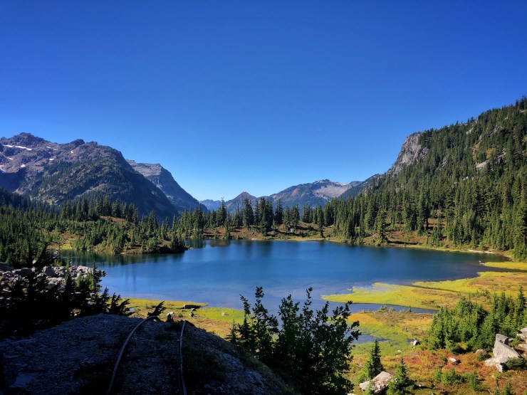
But first, the scenery from the top of the gap looking down at the Chain Lakes is fantastic. This section is also off trail so it’s only you up there. This is priceless.

The navigation until you reach the Chain Lakes is again very straightforward once you know where you are going. I had to check a few times my GPS just to make sure. I am used to get lost even when using a GPS device.
Then comes the downhill to Williams lake. Again, it’s on boulders. So, no running here. Just follow the cairns but stay in the forest on the left going down. It too me a while to figure it out since the last cairn I saw was leading to nowhere.
In the trees, the “trail” goes down with very tight switchbacks. Hang on tight on those branches.
At the bottom, when you almost reach the lake, you’ll find the entrance of the old mine.
Then the trail goes around the lake on the west side to finally find the real trail that will bring me down to the Middle Fork River. That’s a 10-mile downhill of easy trail where I was able to catchup some time.

The only thing was that my stomach started to give me a hard time at that time.
I am using such long run to improve my nutrition and hydration intake. Recently on section J of the PCT my stomach shut down at mile 23 and was not able to eat anything from that moment to the end 50 miles later. That was 8/28 this year.
Since then I changed 90% of my nutrition plan. Switching from 90% spring gels to 90% real food. Simple food and simple sugar is what I am testing for the La Bohn Traverse.


Everything was perfect until it was not. After about 10 hours I felt that my food was staying at the bottom of my stomach. I thought I was not digesting and waited before eating again.
Ate some dried fruit and gummies. I was feeling a bit better. That’s when I stopped drinking because I didn’t want to feel all that water in my belly.
Middle Fork crossing was not that bad.
Then, begins the forever climb. 4 miles of hell. Another mistake I did was to not refill water at middle fork river. There’s no water until maybe 1 mile down on the other side.
You climb 3,480 ft in about 3 miles. I knew it was coming and didn’t want to go too fast on the previous long downhill.
The first part starts along the Middle Fork river with many blowdowns that you need to either go over or under. That’s very demoralizing. Then the switchbacks would bring on a spectacular ridge. Which I thought was Red Pass but as I didn’t see any opening to the other side it didn’t take me long to realize the Pass was still above me.
I was a bit worried about the last stretch. With all the rains in previous days I was concerned the trail would be in good shape.
No way I wanted to backtrack down.
Then Red Pass was in sight and I was over it. Yeah! Now it’s all downhill to the TH.
At the Pass I yelled my son’s name. I wanted him to give my Fanta! But I was alone and his name echoed.


The climb actually took all the calories I had left in my body.
So, of course, I started to dry-heave. I didn’t care as all I wanted was to finish.
At night I passed a hiker and then I heard the vehicles on I-90.
I was done.
Data:
Distance: 29.56M. missing ½ mile from bad GPS at the beginning.
Elevation gain: 9,300 ft.
Duration: Elapse time: 15:01:20. Moving time: 9:31:10.
Strava details: https://www.strava.com/activities/4133674108
